



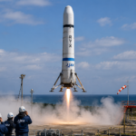



ISRO is preparing to launch the NVS-03 navigation satellite on October 30 from Sriharikota.
The mission is intended to strengthen NavIC, India’s regional positioning, navigation and timing system.
Its significance extends beyond the launch, with attention on satellite availability, an indigenous atomic clock and civilian navigation signals. indianexpress.com
Published: October 29, 2026
India’s next navigation satellite mission comes at an important moment for NavIC. ISRO is preparing to send NVS-03 into space as part of efforts to maintain the satellite infrastructure behind the country’s independent regional navigation system.
For most people, satellite navigation means a location marker moving across a phone screen. Behind that familiar experience are spacecraft broadcasting precise timing signals, ground stations monitoring their performance and receivers calculating where they are.
NVS-03 belongs to that largely invisible infrastructure. Understanding its purpose helps explain why a navigation satellite can matter to transport, surveying and other services long after the launch leaves the headlines.
What ISRO Plans to Launch
NVS-03 is scheduled to launch on October 30 aboard GSLV-F18 from the Second Launch Pad at Satish Dhawan Space Centre, Sriharikota. The date remains a planned launch target until the mission takes place. indianexpress.com
According to ISRO’s official GSLV-F18/NVS-03 mission overview, this will be the twentieth flight of the Geosynchronous Satellite Launch Vehicle. The rocket will carry NVS-03 into a geosynchronous transfer orbit.
ISRO’s mission brochure lists the satellite’s approximate mass as 2,250 kilograms. The planned transfer orbit is elliptical, with a much lower altitude at its nearest point to Earth than at its farthest point. Reaching that initial orbit is a specific launch objective, rather than a declaration that navigation services are immediately ready. isro.gov.in
For readers following the mission, that distinction is useful. Launch performance and the satellite’s eventual contribution to navigation are connected, but they need to be assessed separately.
Why NavIC Needs This Mission
NavIC stands for Navigation with Indian Constellation. Previously known as the Indian Regional Navigation Satellite System, it was designed to provide positioning, navigation and timing across India and approximately 1,500 kilometres beyond its boundary. Its intended services include civilian positioning and a restricted service for authorised strategic users. isro.gov.in
The programme’s operational challenges make NVS-03 particularly significant.
In a parliamentary reply published on July 29, the Department of Space said NavIC had three satellites providing positioning, navigation and timing services after IRNSS-1F completed its mission life. The reply stated that at least four operational satellites were needed for basic standalone positioning.
Consequently, standalone positioning was unavailable at that time, although timing services remained functional. The government also said NavIC was being used alongside other navigation constellations. Press Information Bureau
That July assessment explains the need to replenish the constellation. It should not, however, be presented as a fresh operational status report for October 29.
The implication is that NVS-03 could help address the reported shortfall once operational. A launch announcement alone does not establish that standalone positioning has been restored; that would require confirmation of the satellite’s successful integration into service.
Why the Atomic Clock and L1 Signal Matter
ISRO identifies two notable features aboard NVS-03: an indigenous atomic clock, alongside procured atomic clocks, and an L1 navigation signal in addition to L5 and S-band signals. isro.gov.in
Atomic clocks are central to satellite navigation because receivers depend on precise measurements of signal travel time. A receiver compares signals from several satellites and uses timing information to calculate its position. Small timing errors can therefore affect the resulting location estimate.
NIST’s explanation of GPS illustrates the principle: satellites transmit their time and position, while receivers use the signals’ travel times to work out distances. Accurate, synchronised clocks make those calculations possible. NIST
The L1 signal is relevant to civilian receiver compatibility. ISRO says NavIC’s L1 civilian signal is interoperable with signals from other global navigation satellite systems. That supports devices designed to work with multiple constellations. isro.gov.in
It does not mean every existing smartphone will automatically gain new capabilities after launch. ISRO’s guidance explains that a receiver must support the appropriate NavIC frequencies and decoding. Device compatibility remains part of the picture. Applications
What the Mission Could Mean for Everyday Users
ISRO lists navigation applications ranging from road and rail transport to marine navigation, surveying, precision agriculture and search-and-rescue operations. These uses help explain why maintaining a navigation constellation matters beyond space research. Applications
For users, the eventual benefit depends on a complete working system: operational satellites, supporting ground infrastructure and compatible equipment. A stronger constellation can support those services, but immediate improvements to an individual phone’s accuracy should not be assumed.
The mission also offers a practical way to follow space news. Readers can distinguish between a scheduled flight, successful delivery into the planned orbit and confirmed operational service. Each answers a different question about progress.
That attention to demonstrated capability also runs through our coverage of NASA’s planned Artemis III tests in Earth orbit, where individual mission milestones have distinct purposes.
For broader background on satellites, astronomy and exploration, our parent website’s Space & Universe section brings together accessible explainers.
For NVS-03, the next immediate milestone is the planned flight from Sriharikota. Its longer-term importance will be measured by the navigation capability it helps deliver after reaching space.
Source: ISRO — GSLV-F18/NVS-03 Mission
Read More: Latest News
Read More Interesting Content in My Blog Section of ‘The Thrive Journey’.


